
Tsunami Evacuation Route Mapping in the Tegalkamulyan Area, Cilacap Regency, Based on the Potential of a South Java Earthquake
DOI:
https://doi.org/10.31172/jmg.v26i2.917Keywords:
tsunami modeling, Shallow Water Equations, inundation, mitigation, evacuation routesAbstract
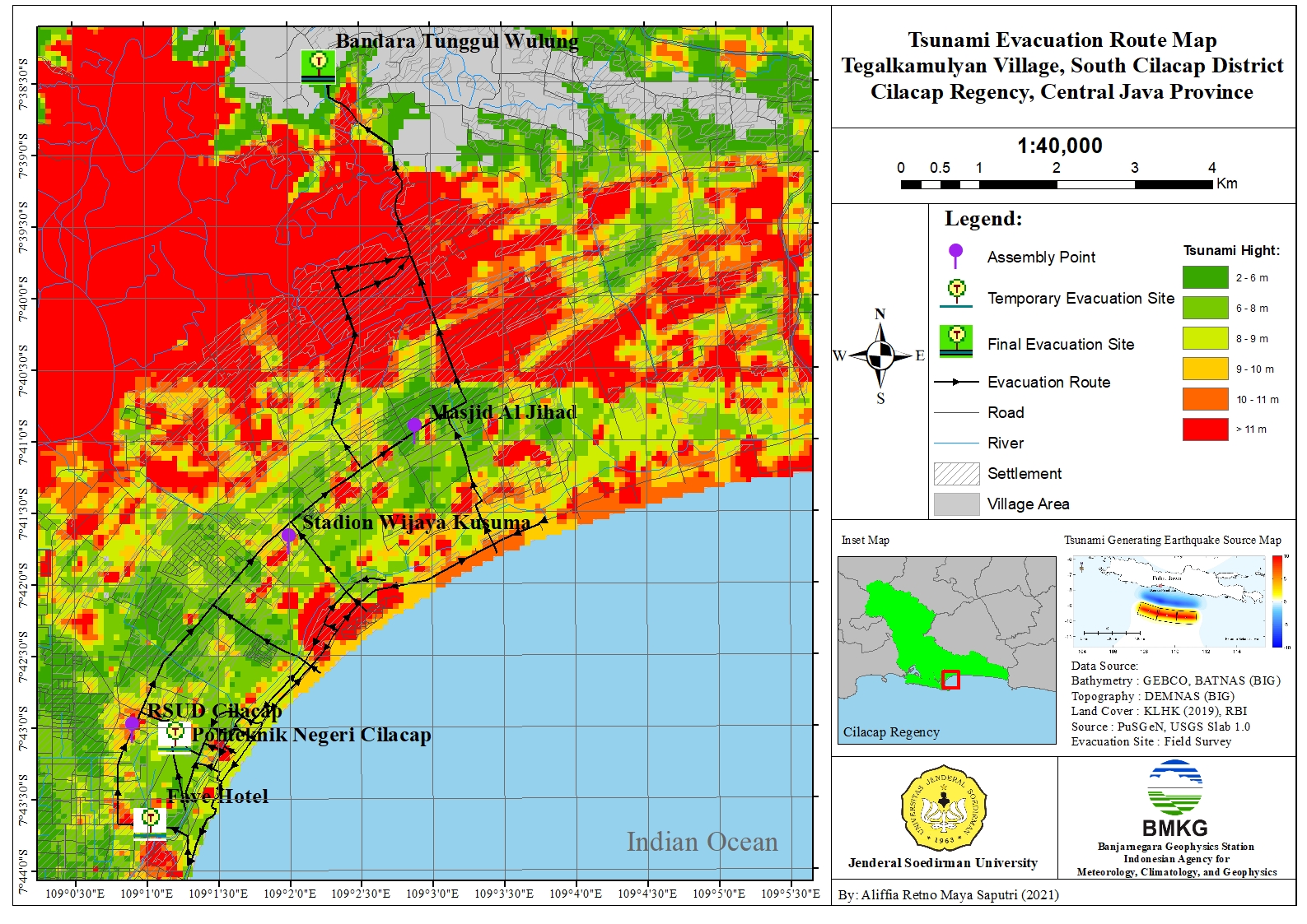
Cilacap Regency is one of Indonesia’s rapidly developing regions, particularly in the oil mining industry, but it is also highly vulnerable to tsunami hazards due to its location along the South Java subduction zone. A major tsunami generated by a large earthquake in this zone would severely impact coastal areas, including the Tegalkamulyan area. As part of disaster mitigation efforts, this study conducted tsunami evacuation route mapping using tsunami wave propagation modeling based on the Shallow Water Equations (SWE). The simulations employed three hypothetical South Java earthquake sources proposed by the National Earthquake Study Center in 2017, with magnitudes up to Mw 8.7. Among these, Scenario 5 represents the worst-case scenario, producing the largest vertical displacement, with a wave uplift of 11.418 m and a subsidence of −7.476 m. The results show that tsunami waves propagate in all directions, with the fastest arrival time reaching the coast 44 minutes and 1 second after the earthquake. The maximum inundation distance extends up to 12.7 km from the coastline, covering an area of 534.890 km², with a maximum run-up height of 30.847 m. Based on the evacuation route mapping, vertical evacuation directs residents to seek tall buildings or Temporary Evacuation Sites within approximately 6–23 minutes on foot, while horizontal evacuation routes guide evacuees from Temporary Evacuation Sites to Final Evacuation Sites within approximately 13–20 minutes using motorized vehicles at an average speed of 38 km/h.
Downloads
References
Aji, L.W. "Identification of Tsunami Evacuation Routes and Locations Based on FEMA P646 at Coastal Tourism Objects in Gunungkidul Regency (Case Study: Nguyahan, Ngobaran and Ngrenehan Beaches)," INERTIA, vol. 16, no. 1, pp. 24-37, 2020.
Banjarnegara Geophysical Station. "Tsunami Hazard Map of South Cilacap District, Cilacap Regency, Central Java Province," BMKG, 2021.
Bedahg, H.T., Rogi, O.H., and Hanny, P. "Analysis of Tsunami Disaster Vulnerability in Palu City," Spatial Journal, vol. 6, no. 2, pp. 432-439, 2019.
Bilek, S. and Lay, T. "Rigidity Variations with Depth Along Interplate Megathrust Faults in Subduction Zones," Nature, vol. 400, no. 6743, pp. 443-446, 1999.
GEBCO Compilation Group. "GEBCO 2021 Grid," 2021.
Geospatial Information Agency (BIG). "National Digital Elevation Model (DEMNAS)," Cibinong: Geospatial Information Agency (BIG), 2018.
GTZ. "Technical Documentation of Tsunami Hazard Map for Cilacap Regency," Cilacap: Cilacap Working Group for Tsunami Hazard Mapping, 2010.
Hanks, T. C., & Kanamori, H. "A moment magnitude scale," Journal of Geophysical Research: Solid Earth, 84(B5), 2348–2350, 1979.
IOC. "Tsunami Glossary," IOC Technical Series, p. 85, 2016.
Kajiura, K. and Shuto, N. "Numerical Modeling of Free-Surface Flows That Are Two Dimensional in Plan," Tsunami in the Sea, no. 9, pp. 395-420, 1990.
Khasanah, L.U., Suwarsito, and Sarjanti, E. "Level of Tsunami Disaster Vulnerability in the South Coast Area of Cilacap Regency," Geoeducation, vol. 3, no. 2, pp. 77-82, 2014.
Khoiridah, S. and Santosa, B.J. "Estimation of Centroid Moment Tensor (CMT), Fault Plane, Rupture Duration, and Vertical Deformation Modeling of Earthquake Sources as a Study of Tsunami Hazard Potential in the South Java Sea," POMITS Journal of Science and Arts, vol. 3, no. 2, pp. 2337-3520, 2014.
Kurniawan, T., & Laili, A.F. "Determination of the Area Affected by the 'Maximum Tsunami Height' on the Island of Bali Based on the Potential for Tsunami-Generating Earthquakes in the Sumba Megathrust Segment," Journal of Disaster Management Dialogue, vol. 10, no. 1, pp. 93-104, 2019.
Kurniawan, W., Daryono, D., Kerta, I.D.K., and Triwinugroho, T. "Analysis of the Tsunami Early Warning System in the Sunda Strait Megathrust Zone to Achieve National Resilience," PENDIPA Journal of Science Education, vol. 6, no. 2, pp. 457-464, 2022.
Latief, H.H., Sunendar, Y.P., and Riawan, E. "Tsunami Inundation Modeling and Mapping and Tsunami Disaster Risk Assessment in Padang City," Bandung: PPKPL, ITB, 2006.
Mardiatno, D., Malawani, M.N., and Nisaa, R.M. "The future tsunami risk potential as a consequence of building development in Pangandaran Region, West Java, Indonesia," International Journal of Disaster Risk Reduction, vol. 46, no. 101523, 2020.
Muqoddas, A. "Analysis of the Effect of Seafloor Roughness on Tsunami Simulation Using the COMCOT Model," Yogyakarta: Gadjah Mada University, 2018.
Muqoddas, M.M. "The Effect of Manning Roughness on Inundation Modeling in Cilacap," Thesis, Tangerang: STMKG, 2018.
National Earthquake Study Center Team. "2017 Map of Earthquake Sources and Hazards in Indonesia," Bandung: Center for Housing and Settlement Research and Development, 2017.
Natsir, A.M. "Tsunami Disaster Mitigation Modeling at Losari Beach," Thesis. Surabaya: Sepuluh Nopember Institute of Technology, 2018.
Papazachos, B., Scordilis, E., Panagiotopoulos, D., Papazachos, C., and Karakaisis, G. "Global Relations Between Seismic Fault Parameters and Moment Magnitude of Earthquakes," Bulletin of the Geological Society of Greece, vol. 36, no. 3, pp. 1482-1489, 2004.
Rahmawati, N.I. "Tsunami Modeling in the Banda Sea and Inundation Implications in the Affected Area," Thesis, Surabaya: Sepuluh Nopember Institute of Technology, 2017.
Satake, K. "Earthquakes and Tsunamis," Tokyo: Earthquake Research Institute, University of Tokyo, 2012.
Susanto, E., Nurana, I., and Setyahagi, A.R. "Tsunami Run-up Modeling in the Coastal Area of West Sulawesi," GAW Bariri Bulletin (BGB), vol. 1, no. 2, pp. 87-93, 2020.
Syukri A. and Mukhlis. "Study of Horizontal Tsunami Evacuation Routes in Padang Pariaman Regency," Civil Engineering, vol. 13, no. 2, pp. 1-12, 2016.
Triatmadja and Radianta. "Tsunami Occurrence, Propagation, Destructive Power, and Mitigation," Yogyakarta: Gadjah Mada University Press, 2010.
Wang, X. "User Manual For Comcot Version 1.7 (First Draft)," USA: Cornell University, 2009.
Wells, D. and Coppersmith, K. "New Empirical Relationship among Magnitude, Rupture Length, Rupture Width, Rupture Area, and Surface Displacement," Bulletin of the Seismological Society of America, vol. 4, no. 84, pp. 974-1002, 1994.
Widiyantoro, S., Gunawan, E., Muhari, A., Rawlinson, N., Mori, J., Hanifa, N.R., Susilo, S., Supendi, P., Shiddiqi, H.A., Nugraha, A.D., and Putra, H.E. "Implications for Megathrust Earthquakes and Tsunamis from Seismic Gaps South of Java, Indonesia," Scientific Reports, vol. 10, no. 1, pp. 1-11, 2020.
Yanagisawa, H. "Numerical Simulation of Tsunami and its Application," Tohoku: Tohoku Gakuin University, 2011.
Downloads
Published
How to Cite
Issue
Section
License
Copyright (c) 2024 Aliffia Retno Maya Saputri, Muhamad Mahfud Muqoddas, Zaroh Irayani

This work is licensed under a Creative Commons Attribution-ShareAlike 4.0 International License.
Authors who publish with this journal agree to the following terms:
- Authors retain copyright and grant the journal right of first publication with the work simultaneously licensed under a Creative Commons Attribution License that allows others to share the work with an acknowledgement of the work's authorship and initial publication in this journal.
- Authors are able to enter into separate, additional contractual arrangements for the non-exclusive distribution of the journal's published version of the work (e.g., post it to an institutional repository or publish it in a book), with an acknowledgement of its initial publication in this journal.
- Authors are permitted and encouraged to post their work online (e.g., in institutional repositories or on their website) prior to and during the submission process, as it can lead to productive exchanges, as well as earlier and greater citation of published work.


